TOUR 1: HISTORY AND HERITAGE
TOUR 1: HISTORY AND HERITAGE
More than four centuries of history have unfolded at the Notre-Dame-du-Cap Shrine. The Faverel River was a meeting place for Indigenous peoples, a parish gathering place, and a Marian pilgrimage site.
- Introduction
- Faverel River
- Nitaskinan Territory
- Seigneuries
- Fort Saint-François
- Creation of the parish
- Shrine
- Third church
- The Oblates of Mary Immaculate
- Way of the Cross
- Rosary Way
- Basilica
Introduction
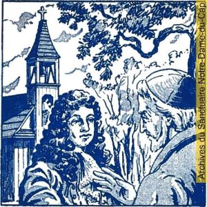
From the Natives to the national pilgrimage site we know today, the history of Our Lady of the Cape Shrine is marked by exciting episodes.
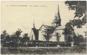
Little is known about how natives occupied the Faverel River’s entrance for millennia, but it was here that, in the mid-17th century, the Jesuits set out to develop a missionary post that would have enabled cultural exchanges if the mission had succeeded. In 1660, a palisaded village was built, the parish church was erected in 1661, a cemetery was opened and at least 18 families settled there. In 1720, a new church was opened. This is currently to this day the Old Shrine. Dedicated to Sainte-Marie-Madeleine from 1720 to 1880, it was reserved for the worship of the Holy Rosary from 1880 onwards, when a third church replaced it. In addition to being the heart of parish activity until 1952, beginning in 1881, the site gradually became the pilgrimage site we know today.
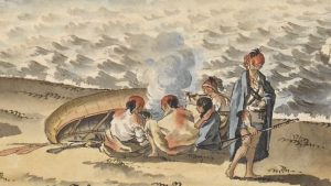
Group of Aboriginals on the banks of the St. Lawrence River at Trois-Rivières in 1784.
(Source of illustration: British Library)
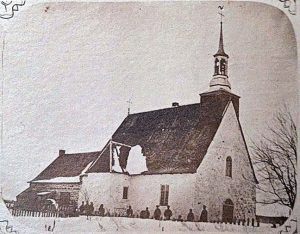
The Old Shrine in 1877, when it was the parish church of Cap-de-la-Madeleine.
(Photo credit: Pierre-Victor Ayotte, René Beaudoin Collection)
Stage 1 – The Faverel River
The Faverel River is a small stream that runs through the site of the Sanctuaire Notre-Dame-du-Cap and empties into the St. Lawrence River. It was here, in 1651, that the Jesuits established a dwelling and chapel.
The origin of the name Faverel is unknown. Some have claimed that the river was named by Jean Poisson in memory of his mother-in-law. This is a mistake, as his mother-in-law was a Fauvel, not a Faverel. The name Faverel River was already known in 1646. Up to Lac Sainte-Marie, the river was canalised for most of its course.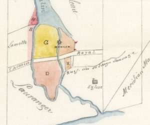
On June 6, 1651, Governor Louis d’Ailleboust de Coulonge and Jesuit Father Paul Ragueneau visited the Cap-de-la-Madeleine settlement established a few years earlier.
(Source of illustration: Journal des PP. Jésuites, January-December 1651, page 127)
In 1863, surveyor Hilarion Legendre identified the Faverel river as the “Wild Village stream”. This is the only mention of this name.
(Source of illustration: Bibliothèque et archives nationales du Québec, file number E9,S101,SS20,SSS1,P11)
Stage 2 – Nitaskinan territory
Before the arrival of the first Emitcikociwicak (the “Whites” in the Nehirowisiwok language), various native nations frequented the Faverel River area, including the Anishinabeg (Algonquin), the Nehirowisiwok (Atikamekw), the Waban-Aki (Abenaki) and the Wendat (Huron).
Today, the Nehirowisiw (Atikamekw) claim the entire Three-Rivers region as part of their ancestral territory, which they refer to as “Nitaskinan” (when speaking to non-Nehirowisiwokok) and “Kitaskino” (when speaking among themselves), meaning “Our Land” in the Nehirowisiwok language, and which encompasses virtually the entire Mauricie region and extends into neighboring regions. This claim is accepted by several other Aboriginal nations. The Three-Rivers territory is also claimed by the Wendat and Mohawk peoples.
The word Nehirowisiwok refers to the individuals of the Nehirowisiw nation, whom the Anishinabeg and others referred to as Atikamekw.
Nehirowisiw is the ethnonym they formalized in 2006. They speak Nehiromowin, the common language of the Algonquian language family. For the Nehirowisiwok, the Saint-Maurice River is called Tapiskwan.
Nitaskinan covers an area of 82,000 km2. It includes the three Atikamekw communities of Manawan, Opitciwan and Wemotaci, as well as the former Kokacik reserve, and the cities of La Tuque, Shawinigan and Three-Rivers.”
(Source: Atikamekw Nation Council, Strategic Plan, Secrétariat au territoire, 2018-2023, page 7)
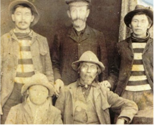
Group of Atikamekw in the 19th century.
(Source of illustration: Conseil des Atikamekw de Manawan website)
Stage 3 – Seigneuries
The seigneury of La Madeleine was granted east of the Saint-Maurice River on January 15, 1636 by the Compagnie de la Nouvelle-France to Jacques de la Ferté, abbot of Sainte-Marie-Madeleine de Châteaudun in France, himself one of the company’s associates. It was 50 kilometers wide at the St. Lawrence River and 100 kilometers deep.
Dividing up his seigneury of La Madeleine, abbot de la Ferté granted six fiefs and seigneuries, including the seigneury of Cap-de-la-Madeleine, which was granted to the Jesuits on March 20, 1651, and of which they took official possession on May 22, 1652. The seigneury is 10 kilometers wide and 100 kilometers deep. The Jesuits already occupied the seigneury. In 1646, Cap des Trois-Rivières, which became Cap-de-la-Madeleine, was reserved for the natives. By 1649, the Jesuits had granted fourteen concessions of two arpents each on the St. Lawrence River.
Map of the seigneuries of the Trois-Rivières government in 1709, including Cap-de-la-Madeleine.
(Source of illustration: Bibliothèque nationale de France)
Stage 4 – Fort Saint-François
In 1660, or perhaps earlier, the Jesuits built a palisade around the settlement that had sprung up on the Faverel River. Fort Saint-François, also known as the “village de la rivière Faverel”, encompassed the first church on the Cape, erected near today’s Old Shrine, and included at least fifteen houses. The fort survived only a few years, but the “bourg du Cap-de-la-Madeleine” continued to exist as the agglomeration and administrative center of the Cape.
There were three forts or redoubts at Cap-de-la-Madeleine: Fort du Moulin, near present-day Rue Jean-Noël-Trudel; Fort Saint-François; and Fort du Village Sainte-Marie, also known as Monsieur Boucher’s Village, near today’s Sainte-Marie-Madeleine cemetery. It was in Fort Sainte-Marie that Pierre Boucher had a chapel built in 1659, which he sold to the Fabrique paroissiale and moved to Fort Saint-François in 1661.
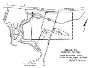
This map shows the location of Fort Saint-François. The small church shown on this map is today’s Old Shrine. The other church, the parish church, no longer exists.
(Source of illustration: Maurice Loranger, Cap-de-la-Madeleine 1651-1986, 1987)
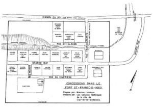
Research by Father Georges Verreault, o.m.i., in the 1950s, taken up by Maurice Loranger, suggests this plan of Fort Saint-François in the 1660s.
(Source of illustration: Maurice Loranger, Cap-de-la-Madeleine 1651-1986, 1987)
Stage 5 – Creation of the parish
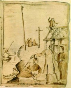
For almost 300 years, from 1661 to 1952, the site of today’s Our Lady of the Cape Shrine, was the nucleus of the parish of Sainte-Marie-Madeleine du Cap-de-la-Madeleine. It was here, inside Fort Saint-François, that the first parish church was built in 1661 and the first cemetery opened. This wooden church was built from the materials of the chapel erected by Pierre Boucher in 1659 on his fief a kilometer to the east. Pierre Boucher’s chapel was dismantled, transported here and rebuilt opposite the present-day Old Shrine. The cemetery was built nearby. In this first church, Mgr de Laval confirmed the children in 1664 and 1666. In 1694, parish priest Paul Vachon founded a Confraternity of the Most Holy Rosary. It was replaced by the present Old Shrine in 1720.
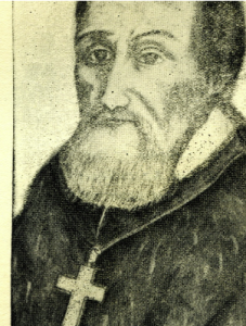
Pierre Boucher sells his chapel.
(Image: Maurice Petitdidier in 1952 or 1953. Archives of the Sanctuaire Notre-Dame-du-Cap)
By comparison, construction of a chapel at the Sault St-Louis Mission circa 1686.
(Image: Claude Chauchetière circa 1686. Archives départementales de La Gironde, France)
Stage 6 – Old Shrine
From its opening in 1720 until 1880, the Old Shrine was the parish church dedicated to St. Mary Magdalene. As early as 1714, Bishop Mgr de Saint-Vallier had expressed the wish that the 1661 church be rebuilt in stone. The governor of Three-Rivers, the bishop himself and other donors from the Three-Rivers and Montreal areas contributed to the financing. As soon as it was built, the parish church included a chapel dedicated to Our Lady of the Rosary.
On September 26, 1880, parishioners bid farewell to this parish church, as the following week saw the inauguration of a new church built in 1879-1880. Immediately, the old 1720 church was entirely dedicated to Our Lady of the Rosary. As pilgrims grew in number, a first annex was built in 1891, replaced in 1904. The present annex was built in 1973 from stones transported in 1879 over the ice bridge that parishioners named the “Pont des Chapelets” (Rosary Bridge).
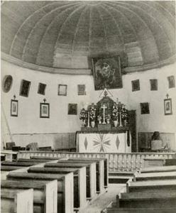
The interior of the Old Shrine until 1888.
(Image source: Canadian Museum of History)
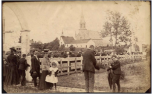
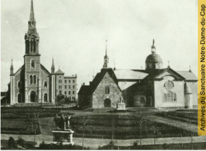
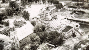
Circa 1900-1903, the Old Shrine and its 1891 annex. In the background, the 1880 parish church.
(Source of illustration: Bibliothèque et archives nationales du Québec)
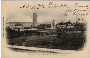
Step 7 – Third church
The 1880 church was built with stones transported in 1879 over the ice bridge formed on the St. Lawrence River following intense prayers by parishioners. That winter, weather conditions prevented the formation of an ice bridge at Cap-de-la-Madeleine. Thanks to the prayers of the parishioners, an ice jam was formed on the evening of March 14, 1879. From March 18 to 26, up to 175 cars crossed the stone loads. Parishioners spontaneously named the bridge the “Pont des Chapelets” (Rosary Bridge).
With the opening of a fourth parish church in 1952, the 1880 church became the Sainte-Madeleine Oratory, reserved for pilgrimages. It was demolished in 1963.
Of the four-bell carillon in 1882, only the bell on display in the Shrine gardens remains. It is the largest and gave the note E flat. It’s name is Marie Madeleine François Léon.
Around 1911, the third church and the 1904 annex to the Old Shrine.
(Source: Our Lady of the Cape Shrine Archives)
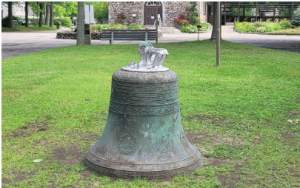
One of the four 1880 church bells, on display in the Shrine gardens.
(Photo: René Beaudoin, 2022)

VIDEO (click on image): In this 2011 video, Jean Normandin tells the story of the Rosary Bridge (10:04 minutes, on YouTube).
Stage 8 – The Oblates of Mary Immaculate
When the former 1720 parish church was consecrated to Our Lady of the Rosary in 1880, little did anyone know that it would become the national pilgrimage center it is today.
By 1879, news of the Rosary Bridge prodigy had spread throughout the region. People began to frequent the site. Newspapers reported a first pilgrimage on September 8, 1882. More and more pilgrimages followed. Father Frédéric Jansoone was appointed manager. After the death of the parish priest and Father Frédéric’s departure, Abbé Duguay found the task is a heavy one. It was a double burden: continuing his work as parish priest and taking on the growing pilgrimage site. On several occasions, he repeats that such a work should be entrusted to a religious congregation. Father Frédéric told the bishop: “Take the Oblates of Mary Immaculate.” They arrived on May 4, 1902.
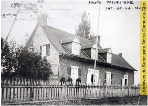
The first Oblates in 1902 in front of the 1861 presbytery, demolished in 1904.
(Source: Our Lady of the Cape Archives)
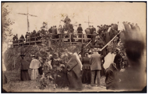
Stage 9 – Way of the Cross
The current Way of the Cross comes from the Martyrs’ Tower at Saint-Célestin. It was first erected at Saint-Célestin in 1933, before being installed at Our Lady of the Cape Shrine in 1974.
This is the third Way of the Cross on the Shrine’s ground. The first is the one designed by Father Frédéric, to which he gave the name “Voie douloureuse” (Painful Path). He said it was built on a third of the model of the one Jesus walked in Jerusalem. Built in wood between 1896 and 1900, it included the 14 stations, as well as the Judicial Gate, the Ecce Homo Arch, the Antonia Tower and the first Tomb or Holy Sepulchre. The 14 stations were replaced by stone monuments in 1913-1916. In 1937, the current Holy Sepulchre was built in stone.
A wooden culvert was built in 1896 to cross the Faverel River and reach the Voie douloureuse (Painful Path). This culvert was replaced in 1907, then in 1924 by the current Rosary Bridge memorial.
This postcard, published around 1902-1904, shows the Painful Path, the Antonia Tower, the Arch of Ecce Homo and the first Holy Sepulchre.
(Photo credit: Pierre-Fortunat Pinsonneault. Bibliothèque et archives nationales du Québec)
This photo, taken around 1900-1903, shows the old calvary, replaced in 1938 by the current one.
(Source: Bibliothèque et archives nationales du Québec)
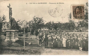
Stage 10 – Rosary Way
The first Rosary group was installed in front of the Old Shrine in September 1905 (moved in the 1960s). It inaugurated the installation of a Rosary Way that would continue from 1906 to 1910. The fifteen bronze groups were cast in France and erected on stone bases. They illustrate the joyful, sorrowful and glorious mysteries.
In 2004, five stations were added, representing the luminous mysteries proposed by Pope John Paul II for the Year of the Rosary (2002-2003). These five ceramic frescoes are the work of Longueuil artist Charles Sucsan.
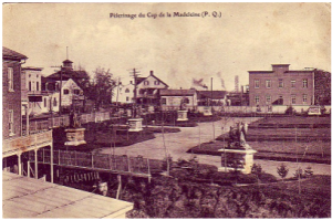
Postcard published around 1908.
(Source: Bibliothèque et archives nationales du Québec)
Postcard circa 1906-1910.
(Source: Our Lady of the Cape Shrine Archives)
Stage 11 – Basilica
The project to build a basilica at Our Lady of the Cape Shrine began in the 1940s. By 1944, architect Adrien Dufresne (1905-1983) was on site. In 1949, the Oblate residence was moved to make way for the basilica. Plans for the basilica were approved in 1951. Groundbreaking ceremony took place on August 5, 1955, by Mgr Georges-Léon Pelletier, Bishop of Trois-Rivières. In March 1957, Father P.-H. Barabé, o.m.i., was in Rome to have the foundation stone blessed by Pope Pius XII. The work lasted nine years. The first mass was held in the basilica on May 19, 1963, and on August 14, 1964, the bishop of Trois-Rivières consecrated the basilica and its main altar.
The basilica is decorated with stained-glass windows by Father Jan Tillemans, o.m.i. The organ was inaugurated on July 4, 1965, and since 1981 the choir has been adorned with a cross hung in front of a red wall hanging.
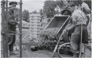
Workers, including Mr. Bourbeau on the left, pour the foundations for the future basilica.
(Collection Ginette Bourbeau)
Built in 1904, the oblates’ residence was moved to its present location on rails using small logs.
(Our Lady of the Cape Shrine Archives)